ORLANDO, Fla. — Tropical Storm Laura will have few intensity changes today, but could quickly intensify over the warm Gulf waters. Marco’s storms displaced over northern Florida, and made landfall near Louisiana late Monday night.
11 p.m. update:
Marco was downgraded to a tropical depression Monday night, according to the National Hurricane Center.
Marco is now moving northwest at 8 mph with maximum sustained winds at around 40 mph.
Marco weakens to tropical depression, may be remnant low by morning. pic.twitter.com/ZM6LXdLomW
— George Waldenberger (@GWaldenWFTV) August 25, 2020
Tropical Storm Laura is now moving off the coast of northwest Cuba, and into the warm Gulf of Mexico.
Laura also brought heavy rains and flash flooding Monday night to western Cuba and is forecast to become a hurricane on Tuesday.
Laura is moving west-northwest at 20 mph with maximum sustained winds at around 65 mph.
*NEW* 11pm: #Laura now over the Gulf, expected to be a hurricane by Tuesday morning. Could be near major hurricane status by landfall LA/TX mid-week. #EyeonTropics. pic.twitter.com/PBWNgOYTdu
— Tom Terry (@TTerryWFTV) August 25, 2020
8 p.m. update:
Tropical Storm Marco made landfall Monday evening near the mouth of the Mississippi River.
Marco is bringing heavy rain and the possibility of tornadoes to a large area of the Gulf Coast.
Marco is moving west-northwest at 8 mph with maximum winds at around 40 mph.
#Marco has made landfall in SE Louisiana as a minimal tropical storm. #Laura winds up to 65mph and will quickly gain hurricane status when it gets over the Gulf and head toward TX/LA border. #EyeonTropics pic.twitter.com/uRt5nDNNZ4
— Tom Terry (@TTerryWFTV) August 25, 2020
Tropical Storm Laura is continuing to move toward the Gulf and if forecast to become a hurricane in the next few days.
Laura is near Cuba, moving west-northwest at 20 mph with maximum winds at around 65 mph.
5 p.m. update:
#Marco decreasing in winds but carries big punch. Heavy rains, storm surge, & tornadoes could develop from #Louisiana to S. #Georgia tonight. #Laura could rapidly intensify once over the Gulf of Mexico. #Hurricane watches from SE #Texas to Central#LAhttps://t.co/JBTdoxstrk pic.twitter.com/rV2ggVMRKZ
— Irene Sans (@IreneSans) August 24, 2020
MARCO:
Marco expected to continue to produce gusty winds and heavy rainfall over portions of the northern gulf coast through this evening. Gusty winds, heavy rainfall, and lingering coastal flooding are expected from Marco along portions of the Gulf Coast through this evening.
HIGH IMPACTS EVEN IF IT IS A SMALL STORM, WIND DECREASE
The greatest threat will be storm surge, reaching up to 4 feet over Louisiana and Mississippi of up to 4 feet.
Marco could also produce 2-4 inches of rain across the parts of the northeastern Gulf of Mexico and some areas could receive up to 8 inches of rain.
Swells are likely to cause life-threatening surf and rip current conditions.
The chance for tornadoes is possible anywhere from the Florida Panhandle to Louisiana even across southern Georgia tonight as Marco moves inland.
Marco still a tropical storm and Laura moving closer to the Gulf. Here's the #EyeOnTheTropics update for Monday 5pm. #WFTV #Florida pic.twitter.com/GBvVTubu9Y
— George Waldenberger (@GWaldenWFTV) August 24, 2020
LAURA:
Tropical storm conditions and heavy rainfall are expected across Central and western Cuba through tonight. These rains could cause mudslides and life-threatening flash and urban flooding. The center of Laura is near Isla de la Juventud in Cuba, this is an island located south of the northwestern tip of Cuba.
Laura will likely continue to become better organized and once it emerges over the Gulf there is a chance that this system could go through rapid intensification as there will be plenty of fuel (warm waters) and very low wind shear. Laura will likely make landfall somewhere along the Texas and Louisiana border late Wednesday night. Wind, storm surge, and rainfall hazards will extend far from the center. Hurricane conditions are possible by late Wednesday from Port Bolivar, Texas, to west of Morgan City, Louisiana, with tropical storm conditions possible by Wednesday afternoon, and a hurricane watch has been issued.
4 p.m. update:
Expect the next complete advisory from the National Hurricane Center to be released at 5 p.m. There could be a track shift for Laura as it has remained offshore, south of Cuba, and some imagery is showing that the center might have reformed.
We will bring you the latest on our newscast starting at 4 p.m., on WFTV.com and on our Free WFTV Weather app.
It's hard to believe we're probably only 'halfway' through the season's expected number of storms - and nowhere close to the amount of hurricanes and major hurricanes forecast. From here on, we'll see a lot of storms become hurricanes which is normal. #EyeonTropics pic.twitter.com/YpOMOThwzU
— Tom Terry (@TTerryWFTV) August 24, 2020
3p.m. update:
LIVE: 3pm Tropical UpdateAn active tropics with Tropical Storm Laura and Tropical Storm Marco. Laura expected to become a big storm in the Gulf of Mexico. See track and impacts: at.wftv.com/3hr7skn
Posted by WFTV Channel 9 on Monday, August 24, 2020
11 a.m. update:
Tropical Storm Marco continues to be greatly dented by wind shear, most of its thunderstorms have been displaced to the northeast, traveling over the Florida Panhandle. Expect Marco’s center to continue moving to the north-northwest at about 8 mph, likely making landfall in Louisiana late Monday or very early Tuesday morning. The greatest threat will be storm surge, reaching up to 4 feet over Louisiana and Mississippi of up to 4 feet. Marco could also produce 3-6 inches of rain across the parts of the northeastern Gulf of Mexico and some areas could receive up to 10 inches of rain. The chance for tornadoes are possible anywhere from the Florida Panhandle to Louisiana tonight as Marco moves inland.
Little change in strength is forecast today, but there will be no stopping once it enters the Gulf of Mexico. The main threats will be winds, rain (flooding) and life-threatening storm surge. Also, tornadoes could form mainly east of the system’s center. pic.twitter.com/orqA8o4FaY
— Irene Sans (@IreneSans) August 24, 2020
Tropical Storm Laura is still over the Caribbean, paralleling Cuba’s southern coast. Since Laura continues to move over water, the system will likely continue to intensify as it approaches the northwestern tip of Cuba. By Tuesday morning, the strong tropical storm would be over the Gulf of Mexico without nothing to stop it from intensifying through the middle of the week. Laura could reach category 2 status as it moves closer to the Louisiana and Texas border, where it will likely make landfall late Wednesday night. There could still be some changes in the track, perhaps a bit more west or east, but Laura should make landfall anywhere from Central Louisiana westward to southeastern Texas on Wednesday evening.
The main threats will be winds, rain and life threatening storm surge. Also tornadoes could form east of the system’s center.
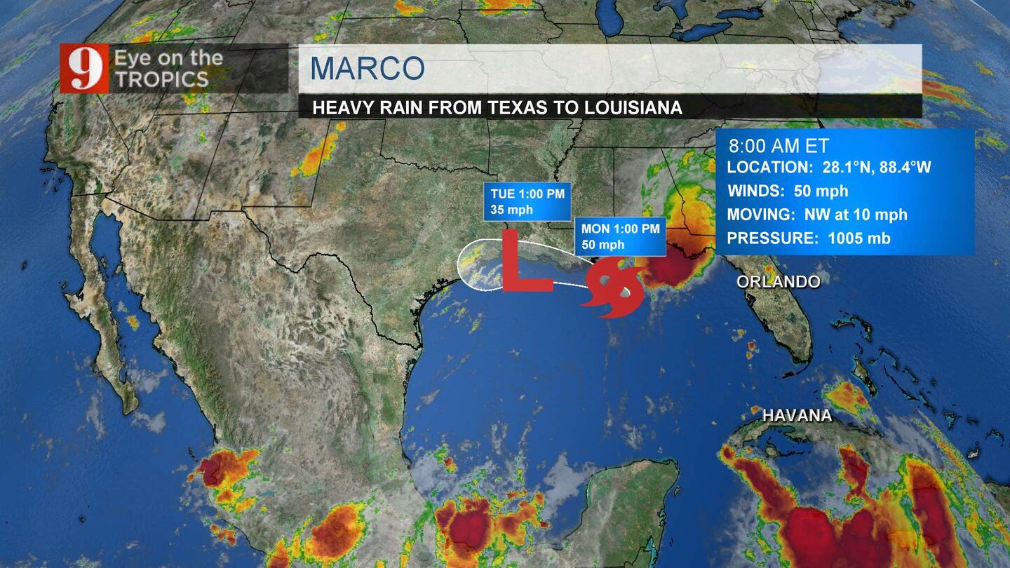
8 a.m. update
Tropical Storm Marco continues to weaken as it continues to move toward the Louisiana/Texas border.
The storm is moving northwest at 10 mph, with 50 mph winds.
Meteorologist Brian Shields said the storm is falling apart.
Meanwhile, not much has changed with Tropical Storm Laura. The storm is moving west northwest at 21 mph, with 65 mph winds.
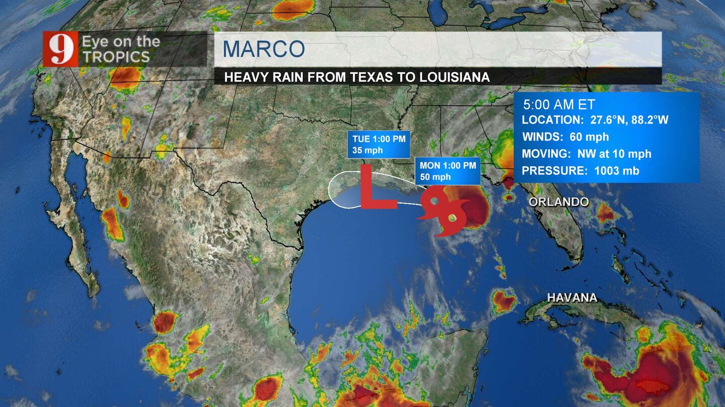
4:30 a.m. update
Tropical Storm Marco was downgraded to a tropical storm and continues to weaken in the northern Gulf of Mexico.
Marco is moving north northwest at 12 mph. Its winds are at 65 mph.
Meteorologist Brian Shields said Laura will become a hurricane once it emerges in the Gulf of Mexico. Laura will move toward the Louisiana/Texas boarder Wednesday. At that point it could be a strengthening hurricane, with winds over 100 mph.
Laura is moving west northwest at 21 mph. Its winds are at 65 mph.
Neither system is near Central Florida and neither system will have an impact on Central Florida.
Follow our Severe Weather team on Twitter for live updates:
- Chief meteorologist Tom Terry
- Brian Shields
- Irene Sans
- Kassandra Crimi
- George Waldenberger
- Rusty McCranie
Cox Media Group


 Sign Up

